Why did North India receive an unexpectedly high rainfall
Decoding the Deluge: Unraveling the Unprecedented Rainfall in North India
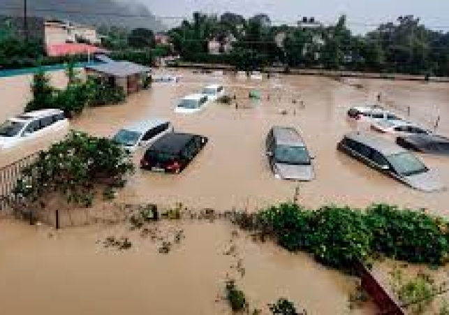
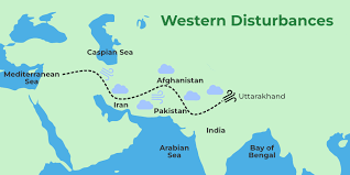
In the past couple of days, North India, including Himachal Pradesh, Uttarakhand, Punjab, and Haryana, experienced an unusually high amount of rainfall. This rainfall was a result of the interaction between a weather system called the western disturbance and the monsoon trough. As a result, these regions witnessed landslides, flash floods, and significant damage to infrastructure such as highways.
Interestingly, until the end of June, there was a 10% deficiency in rainfall across the country. However, in the past week, the monsoon brought a surge of rainfall to the west coast and parts of northern India, resulting in a 2% excess rainfall overall on July 9, according to the India Meteorological Department. Specifically, northwest India experienced a staggering 59% excess rainfall, while central India saw a 4% excess. On the other hand, peninsular India faced a 23% rainfall deficiency, and east and northeast India witnessed a 17% deficiency.
Several places in Haryana and Punjab were severely affected by heavy rainfall, with record-breaking numbers. For instance, Chandigarh received 32 cm of rainfall, Ambala 22 cm, Delhi 15 cm, Nangal 28 cm, and Ropar 27 cm. Similarly, Himachal Pradesh's Bhuntar recorded 10 cm and Mandi recorded 8 cm of rain during a single day, resulting in a staggering 1,193% excess rainfall compared to the normal average. Punjab also faced a significant excess of rainfall, with 57.5 mm recorded against the normal average of 4.6 mm, indicating a 1,151% excess for the day.
ALSO READ: Devastating Floods Hit Punjab as Rivers Overflow
CAUSES OF HEAVY RAINFALL
The heavy rainfall was primarily attributed to the interaction between the western disturbance and the monsoon. M Mohapatra, director general of the weather bureau, explained that this interaction caused heavy to very heavy rainfall in Jammu and Kashmir, Himachal Pradesh, north Punjab, Haryana, and Uttarakhand. He also mentioned that the forecast had predicted good rainfall in July, which has now helped overcome the rainfall deficit. Furthermore, experts noted that the recent floods in Himachal Pradesh resembled the 2013 Uttarakhand floods, suggesting similar weather conditions.
ALSO READ: Chandigarh Drenched in Record-Breaking Deluge of 302.2 mm Rainfall in 24 Hours
Climate scientists have emphasized the impact of climate change on monsoons, noting that heavy rainfall events have become more intense, even though they occur for shorter durations. Due to global warming, hilly areas like the Himalayan foothills and the Western Ghats are particularly prone to heavy rains and landslides. These regions experience orographic lifting, where the hills obstruct the flow of moisture, causing it to accumulate and result in heavy rainfall. Such extreme rainfall events are difficult to predict, and monitoring systems, including radars, need to be enhanced to mitigate their effects.
The heavy rainfall is expected to continue over Himachal Pradesh, Uttarakhand, and the northwestern plains for at least the next 24 hours. It will gradually reduce thereafter but may persist over Uttarakhand, Uttar Pradesh, and parts of Bihar. The monsoon trough is shifting toward the Indo-Gangetic Plains. The current intense spell is primarily due to the interaction between the western disturbance and the monsoon, but normal rainfall patterns are anticipated to resume in northwest India.
Overall, the recent heavy rainfall in North India serves as a reminder of the impacts of climate change on monsoons, highlighting the need for improved forecasting and mitigation strategies.
Related News