Uttarakhand to survey Glacier lakes in 2025
Uttarakhand to conduct survey of four high-risk glacier lakes this year
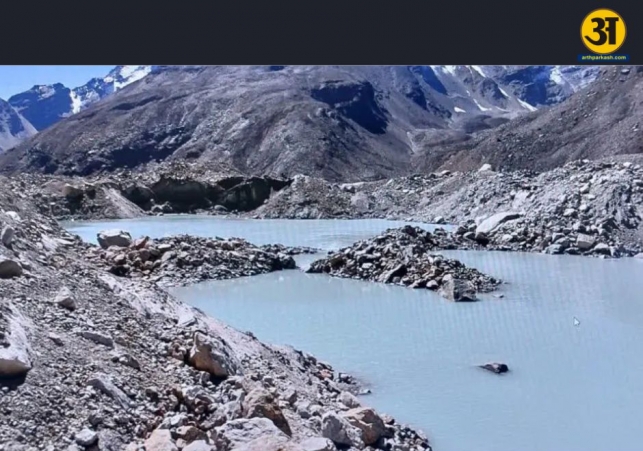
The Uttarakhand State Disaster Management Authority (USDMA) has announced plans to survey four high-risk glacier lakes in Pithoragarh district this year. This initiative is part of the ongoing efforts to assess and mitigate the potential threats posed by glacier lakes in the region. The decision follows last year’s survey of Vasudhara Glacier Lake in the Chamoli district.
Identifying high-risk Glacier Lakes
A total of 13 glacier lakes have been identified across Uttarakhand, with five categorized as highly sensitive under Category A. These lakes pose significant risks due to their potential for flooding or glacial lake outburst floods (GLOFs). Among the identified lakes, one is located in Bageshwar, four in Chamoli, six in Pithoragarh, one in Tehri, and one in Uttarkashi.
The survey aims to study the depth, width, drainage routes, and volume of the glacier lakes, enabling authorities to design effective risk mitigation strategies. According to Vinod Kumar Suman, Secretary of the Disaster Management Department, a foolproof monitoring system is being developed in collaboration with multiple scientific and response institutions.
ALSO READ: Sanctioned trophy hunting: the controversial grey area in man-animal conflict
ALSO READ: Justice G Narendar sworn in as Chief Justice of Uttarakhand High Court
USDMA is working closely with the Indian Institute of Remote Sensing (IIRS), Wadia Institute of Himalayan Geology, State Disaster Response Force, National Disaster Response Force, and Indo-Tibetan Border Police. These agencies bring together expertise in geology, disaster response, and remote sensing to ensure comprehensive monitoring and data collection.
Necessary equipment like water level sensors, automatic weather stations, and thermal imagers will be installed to monitor the glacier lakes. The team aims to collect real-time data to identify potential risks and initiate protective measures promptly.
Phased survey and early warning systems
In the first phase, experts will assess the physical characteristics of the lakes, including their sediment levels and changes in volume. This will be followed by the installation of early warning systems and other scientific instruments to track ongoing changes in the glacier lakes.
Former scientist DP Dobhal emphasized the importance of continuous monitoring and protective measures to minimize risks associated with these lakes. Remote sensing technologies will play a crucial role in tracking changes and sharing data among institutions.
The initiative to survey high-risk glacier lakes in Uttarakhand is a critical step towards disaster preparedness and risk reduction. By leveraging technology and collaboration among scientific bodies, USDMA aims to safeguard the region against potential glacial hazards. This comprehensive approach ensures that timely and effective protective measures can be implemented to protect both lives and livelihoods in vulnerable areas.


